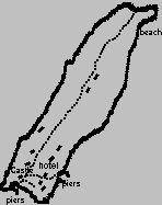
(https://web.archive.org/web/20080921112627/http://www.incallander.co.uk/islands.htm)
Loch Lomond is 18 miles long and 4½ miles wide at the broadest point.
The deepest point is 630 feet. The Loch, especially at its southern end is dotted with a host of islands of all shapes and sizes.
There are about sixty islands in total, depending on the water level as some will disappear as the water rises whilst others only appear at very low water levels.
All of the islands are owned by someone. While most owners are fairly tolerant of responsible visitors, jetties and slipways are almost all private.
If you visit any of the islands, remember that the country code applies here on the islands just as on the mainland. Litter should be taken home with you when you leave, animals both domesticated and wild should not be disturbed, trees and other plants should not be damaged or uprooted and the rights and comfort of other people 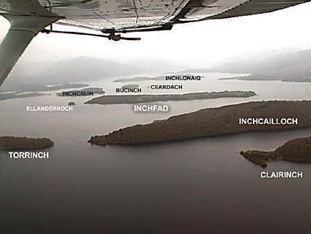 should be respected.
Having said all that, when you visit any of the islands, enjoy the seclusion, the peace and the sometimes interesting ruins of houses, castles and religous buildings which are to be found on many of these islands.
There are too many islands in the loch to describe all of them so I will describe (in alphabetical order) the most important and most interesting.
Much has been said about the Scot’s hallowed ‘right to roam’ and unfortunately some take it to mean ‘right to go where I wish and do as I please’.
The right to roam means you may roam where you wish with the exception of land classed as ‘private garden space’ but does not over-ride the ‘country code’ which basically means treat the land and its occupants with respect and don’t cause damage to property, crops and livestock.
If you camp in the wild, clean up after you and in this way ensure that the right to roam continues for the benefit of ourselves and generations to come
|
## Bucinch (island of goats)
Bucinch has a central summit, but there is no viewpoint as the whole island is covered by trees. Scots pines cling around its shores, here and there with birch and rhododendron while inland there is birch, oak and rowan, and almost everywhere a thick carpet of blaeberries. Fixed to a rock on an eastern shore is a little plaque recording the life and death of a young man who must have loved this place. On the east bank is a memorial to 4 Clyde shipyard workers who drowned.
At the southern corner of the island there used to be a small hut for fishermen, the foundations of which still remain, and nearby are the remains of a jetty formed by very large boulders.
Gifted to the National Trust for Scotland by Colonel C L Spencer, Bucinch is
unrestricted, unsignposted and largely unspoiled.
|
|
|
## Clairinch & Keppinch
Just east of Inchcailloch, Clairinsh is flat, especially when compared with its almost mountainous neighbour.
Although small and insignificant looking, Clairinsh is important in local history, for in 1225 the Third Earl of Lennox, the owner of much of the southern part of Loch Lomond, gave the island to his clerk named Buchanan, who had to pay an annual rent of one pound of wax.
This was the first land owned by a Buchanan, but the clan grew strong, and until 1682 held much of east Loch Lomond side.
Clairinsh was purchased in 1682 by the Third Duke of Montrose, and it remained the property of this family for the next two hundred and fifty years.
Clan Buchanan still looked towards this small island as the birthplace of their grandeur, and over the centuries had honoured it by using its name as their battle slogan "Clar Innis!" In 1934 they acquired it for the Buchanan Society, and today Clairinsh is part of the Loch Lomond Nature Reserve.
Just off the northernmost point of Clairinsh lies a tiny manmade island or crannog, known as Keppinch or The Kitchen. This was created in pre-historic times by driving poles into the bed of the loch and building a platform then a shelter upon an infill of boulders. See a modern re-creation at Kenmore on Loch Tay.
|
|
|
## Ellanderroch
This tiny 'Island of Oak' is just over 100 metres at its widest point and is separated from the larger Inchfad island by only a few yards of shallow water. There are some large oaks on the island, surprisingly for its small size. One of the oaks was at some time in the past hollow and weakly and was reinforced by filling with concrete. The tree was later struck by lightning and burnt away to leave the concrete the only remaining evidence of the tree.
The fishing is reputed to be good hereabouts and the island is much frequented by fishermen who take refuge here when cought by the many unexpected squalls.
A former owner of Inchfad sold up but retained ownership of Ellanderrach so that he still had a 'bit of Scotland'. It is now privately owned by the owners of the larger Inchfad.
|
|
|
## Fraoch Island
Near Luss on the western shore of the Loch lies this small, very picturesque rocky island, a mere 150 metres long and only about 12 metres high. When the heather is in bloom you can understand why it is named 'Fraoch', or heather island.
Lightly wooded with birches and brambles, its soil is thin and dries out quickly so that the russets of Autumn appear here earlier than elsewhere.
On Charles Ross’s 1792 Plan of Dunbartonshire, Loch Lomond and its Environs, Fraoch is shown as ‘Luss Prison’. Near to Luss yet isolated by the water it would be a simple temporary solution to the undesireables of the day. It is also said that Fraoch island was used to cure nagging wives and on a miserable wet Loch Lomond day, not many would willingly invite a second visit!
Fraoch is often given another name, 'Inchfrielechan'. This is possibly derived from 'Inch-FraochEilean', meaning 'island-heather-island'- heather island in two languages - Scots and Gaelic. Privately owned.
|
|
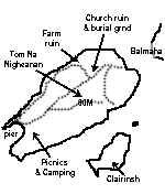
## Inchcailloch
From the mainland at the Balmaha pier, this is one of the most accessible of Loch Lomond’s islands.
In 717AD three Irish Christian missionaries arrived in Scotland. They were St
Kentigerna, (mother of St Fillan), and her brother and son. The old woman settled on the island, which because of her became known as Inchcailloch or 'The Island of the Woman'. In the 12th or 13th century a church was built and dedicated to her memory. To this church for 500 years, from the twelfth to the seventeenth century, the people of the mainland parish, now known as Buchanan and then called Inchcailloch, rowed across to their Sunday worship, and here also they buried their dead. In 1670 the church on Inchcailloch was finally abandoned, but the graveyard continued to be used, the last burial being in 1947.
Situated about a quarter of a mile above the landing place opposite Balmaha pier, the foundations of the church are still visible, and many gravestones from more recent times are still legible.
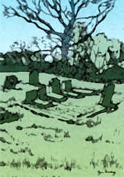 Inchcailloch was the burying place of the Clan MacGregor, but the most common name is MacFarlane. Among the grave stones are two old ones to a MacGregor and to a MacFarlane, Gregor MacGregor 1623 and Duncan MacFarlane 1783.
The latter bears the slogan Loch Sloy. Gregor McGregor was clan chief and an uncle of Rob Roy MacGregor.
The remains of the houses of the original inhabitants can be found on the north-west side of the island, near to the shore. The farm lease was last renewed before 1800, so it farming was probably abandoned about then.
Oak bark was used for the production of leather tanin, while the wood yielded acid at a factory in Balmaha.
Now owned by Scottish Natural Heritage, Inchcailloch is a delight to the visitors who follow the nature trail on Inchcaillach to the top of the wee hill called Tom na nighean, (hill of the young women). From the summit viewpoint, surrounded by heather and sheltered by Scots pines, all the major islands of the Loch can be seen stretching away to Ben Lomond on the east and Ben Vorlich on the west side. To the south of Inchcailloch is the sandy bay of Port Bawn. Here you'll find a jetty and picnic area.
Inchcailloch was the burying place of the Clan MacGregor, but the most common name is MacFarlane. Among the grave stones are two old ones to a MacGregor and to a MacFarlane, Gregor MacGregor 1623 and Duncan MacFarlane 1783.
The latter bears the slogan Loch Sloy. Gregor McGregor was clan chief and an uncle of Rob Roy MacGregor.
The remains of the houses of the original inhabitants can be found on the north-west side of the island, near to the shore. The farm lease was last renewed before 1800, so it farming was probably abandoned about then.
Oak bark was used for the production of leather tanin, while the wood yielded acid at a factory in Balmaha.
Now owned by Scottish Natural Heritage, Inchcailloch is a delight to the visitors who follow the nature trail on Inchcaillach to the top of the wee hill called Tom na nighean, (hill of the young women). From the summit viewpoint, surrounded by heather and sheltered by Scots pines, all the major islands of the Loch can be seen stretching away to Ben Lomond on the east and Ben Vorlich on the west side. To the south of Inchcailloch is the sandy bay of Port Bawn. Here you'll find a jetty and picnic area.
|
|
## Inchconnachan (Colquhoun's Island)
Inchconnachan has a coastline of small secluded bays. In the summer these havens attract yachts, cruisers, and day trippers who picnic on their shores.
The narrow strait between Inchtavannach and Inchconnachan is said to be the most beautiful place on the loch. Alocal historian once observed that although from time to time the Loch southwards of Luss was so frozen "as to allow men with horses and loaded sleds to go from each side to the islands" yet at no time, not even in the great freeze of 1740, did this strait freeze over, despite being nowhere more than 2.5 fathoms and having no perceptible current. A trip through the narrows as it is popularly known, is a must for anyone exploring Loch Lomond!
The name of the island is thought to have been derived from a corruption of the name of the Clan who inhabited it - 'Colquhoun'. Being so very near to the bridge towards the mainland formed by Inchtavannach, early peoples must have found their way to Inchconnachan, and some must have settled here from time to time, but we have little evidence of their occupation. There may have been a settlement at the north end of the narrows, and a round structure, possibly a grain drying kiln, has been found. There is also a story of illicit whisky makers from Luss working their stills during the last two centuries.
There is a bungalow near to the narrows. This was once the holiday home of Lady Arran, sister of Sir Ivan Colquhoun, and who was once the holder of a power boat speed record! The bungalow was built in the 1920s by a retired Admiral, who was known as Admiral Sullivan , and who it is said brought electric power to the island. It is also said that when his business collapsed, he went to live in the dungeon of 'Island I Vow' at the north end of the Loch.
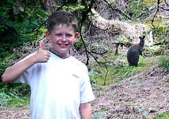 Some wallabys were once released onto the island and some of their decendants still frequent the place.
I have yet to see one, but a site visitor recently emailed me to assure me that she has frequently seen the animals and that her children have seen 'droppings' of evidence!
Thank you Claire for the information.
More recently other visitors have confirmed sightings and one send this photographic evidence:
¾ of a mile long, highest point 150 ft. Privately owned.
Some wallabys were once released onto the island and some of their decendants still frequent the place.
I have yet to see one, but a site visitor recently emailed me to assure me that she has frequently seen the animals and that her children have seen 'droppings' of evidence!
Thank you Claire for the information.
More recently other visitors have confirmed sightings and one send this photographic evidence:
¾ of a mile long, highest point 150 ft. Privately owned.
|
|
|
## Inchcruin (Round Island)
Inchcruin is mostly wooded and has a couple of sandy bays at the south east. The rest
of the shore os rocky. Almost touching Inchmoan at the strait called 'the geggles' it can
be reached on foot from Inchmoan at low water levels.
It was farmed until the mid 19th c and a cottage at the east side may be a holiday home
of the owners.
One of the island's past owners once kept an ex-US army truck on the island - and used
it even in the absence of roads.
Privately owned, ¾ mile long, highest point 50 ft.
|
|
|
## Inchfad (the Long Island.)
Unexpectedly, on this island you will find a short canal near the north eastern tip.
This was used in the past to provide access by boat to the island's distillery - a legal
one for a change in these parts. The distillery is now closed but the wee canal is used as
a harbour by the island's owners.
Easily accessed from Balmaha, Inchfad has been populated by farming families for
generations, and houses with outbuildings can testify to the fact. A past attempt by
previous owners to set up a caravan holiday resort here failed and the island reverted to
farming.
Livestock in the form of local deer still visit the island, attracted by the rich
grazing on the once cultivated land.
Privately owned, 1 mile long, highest point about 70 ft.
|
|
|
## Inchgalbraith
A miniscule island, probably once a crannog. Once occupied by the Galbraiths from Glen
Fruin who built a castle here. The remains of the castle can still be found, in fact, you
can't miss them as they occupy most of this tiny island.
Privately owned, length - short. Height about 25 ft.
|
|
|
## Inchlonaig (Yew tree Island)
The yew trees after which this island is named are reputed to have been re-planted by
King Robert the Bruce after using the wood for the bows of his archers. The island itself
was owned for centuries by the Colquhouns who farmed deer here.
A stonebuilt cottage and some ruined lime kilns are to be found on the south side by
the bay. The cottage was once used by the last Colquhoun resident who farmed the island .
A previous Colquhoun, James, and a boy, both gamekeepers were drowned at whilst returning
from a deer hunt on Inchlonaig in 1873. Mesolithic remains were found on the east side.
With a length of about a mile and a maximum height of about 200 feet Inchlonaig offers
some picturesque views over and through the yew trees
Privately owned and a Site of Special Scientific Interest.
|
|
|
## Inchmoan (peat island)
Another island once owned by the Colquhouns of Luss, and now owned by Luss Estates. A large 2 storey ruin stands at the western point but no record exists of any occupants.
The name of the island stems from its use by the Luss people as a source of Peat fuel for the village fires.
The beaches and bays are sandy and comparatively safe for bathing but the interior is, in places, totally impassible due to the dense growth of rhodedendrons, gorse and other spreading trees.
Privately owned, 1 mile long, highest point about 30 ft.
|
|
|
## Inchmurrin (St Murrin's island)
The largest island on Loch Lomond, with a length of about 1½ miles and a highest point of about 300 ft, some pleasant beaches and several piers.
At the southern end stand the ruins of Lennox Castle to which the Earl of Lennox and his family retreated from Balloch in order to escape the plague. Isabella, countess of Albany was exiled here after losing all her male relatives to the executioner's axe at Stirling in the 15th c.
The name Inchmurrin comes from the chapel to St Mirren which is said to have been at the southern end near the castle site. No remains have been found.
For years the island was the private deer park of the Duke of Montrose but was sold in the early 20th c when some bungalows were added to the housing stock which amounted to one keepers house! Inchmurrin was once renowned for its whisky until the government produced an exciseman's cutter to the loch and various skirmishes were reported!
Inchmurrin is now farmed and has some timber lodged used by visitors who come over on the privately operated ferry service.
Privately owned
|
 |
</td>
</tr>
</table>
</td>
</tr>
|
|
## Inchtavannach (Island of Monks)
Here at Ton-Na-Clag it is said that monks tolled their bell to call the faithful to worship at the monastery. More recently, Victorian visitors carved their names on the rock at the summit.
There is also believd to be an association with St Kessog who was killed at Bandry Bay south of Luss.
The Producer of 'Tak the High Road' lived for 10 years in the house which now stands on the site of the monastery.
. |
 |
## Isle of Inveruglass
This is the 'Island of the Black Stream', the stream being the Inveruglas water which
decends the hillside from Loch Sloy past the ruins of the summer shielings. The stream
enters the loch just to the south of Inveruglas village.
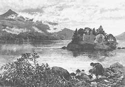 The Island's trees hide the ruins of the Clan MacFarlane's castle to the east. The castle was sacked by Oliver Cromwell in the 17th C.
Privately owned, length - wee, height - what height!
Illustration above shows Inveruglass Island and the castle as it was in the late 19th
c.
The Island's trees hide the ruins of the Clan MacFarlane's castle to the east. The castle was sacked by Oliver Cromwell in the 17th C.
Privately owned, length - wee, height - what height!
Illustration above shows Inveruglass Island and the castle as it was in the late 19th
c.
|
|
|
## Eilean I Vow (Eilean à Bhuth)
Another tiny island in the centre of the loch at the narrow northern end and mid-way
between Ardlui and Inversnaid.
Small and tree covered it may be, but it has at its south end the remains of yet
another MacFarlane castle, this one built to replace that destroyed by Cromwell at
Inveruglas Island. The castle is now overgrown with trees and ruined but in 1710, Buchanan of Auchmar described it as 'a pretty good house with gardens'.
|
|
|
## Tarbet Isle (Isle of the Portage)
Tarbert is a Gaeilg/Gaelic word meaning, literally 'to carry over' or 'portage', a place where boats could be dragged or carried over a narrow strip of land.
The 'Portage' in this case is the narrow strip of land between the north end of Loch Long and Loch Lomond where the Viking King Haakon's men used the portage to bring their longboats to wreak havoc among the communities of Loch Lomond. Justice was forthcoming - on their way to rejoin the fleet of Haakon they lost 10 ships in a storm on Loch Fyne and were then destroyed at the Battle of Largs.
Tarbet Isle is just off and to the north of the village of Tarbet.
|
|
</table></td>
</tr>
</table>
</div>
</div>
.
|